
Sun Jun 30, 2013 11:14 pm
#1180220
Those who also see me waffling on Facebook will already know that myself, my flying partner and Rhubarb The X'Air ended up having an off-airfield landing yesterday after getting caught out by the weather.
Perhaps less discussed than post-engine failure arrivals into fields is the precautionary landing under power in that situation, yet we weren't in fact the only aircraft from our strip to need to do it yesterday, from two different departure points yet ended up close together in different farmers fields.
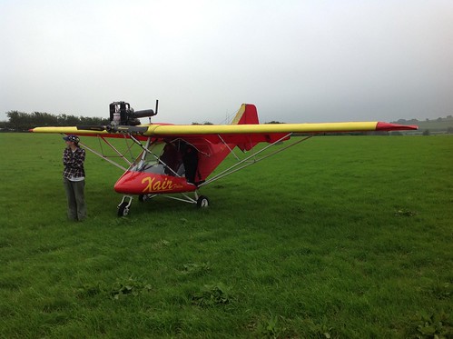
Hurt to nothing but pride (and bird doings on the aircraft which had to spend a night without her covers), we flew back today, but the other chap's awaiting a field trim before he can get out again.
I'm still trying to figure out what it was in the forecast that all three of us missed to find ourselves there. Amazing the data there is to pull through!
The TAF I got before leaving for the strip at midday was
EGFF 291102Z 2912/3012 29010KT 9999 SCT040
TEMPO 2915/2918 8000 BKN008
BECMG 2918/2921 8000 BKN006
PROB30 TEMPO 3000/3006 4000 BR BKN004
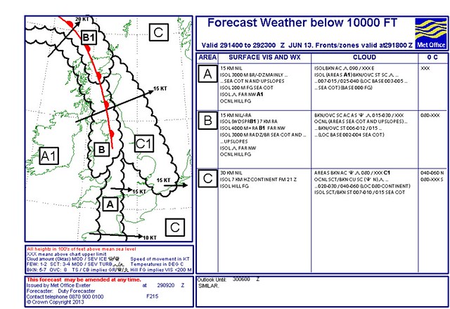
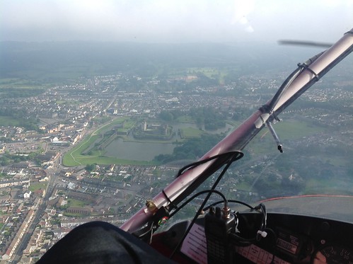
I frowned slightly over the "TEMPO 8000 BKN008" but the 'out the window' looked good, we were in no hurry and had no especial need to commit to a particular route and could dodge any nastiness. The 215 as far as I could see, concurred with much use of "Isolated" and "On Hillslopes" and "Coastal". Our strip's both and there was some cloud clinging to the hilltop but it was clearly visible and easy to dodge and once we were up we were past it and under blue skies in minutes.
215
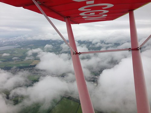
Cloud along the ridge
With hindsight I completely failed to register the BECMG which proved to indeed become important. Because it was 1 o'clock we planned to fly - who cared what happened coming on 7...
Except we didn't actually leave until 4, didn't check the updated NOTAM at our destination, another little strip Cemais Commander, half hour away because the sky and conditions looked to the eye unchanged.
If we had looked again, we'd have seen this:
EGFF 291659Z 2918/3018 28015KT 9999 SCT008 BKN012
TEMPO 2918/2921 6000 BKN006
PROB40 TEMPO 2918/3006 4000 BR BKN004
PROB30 TEMPO 2921/3006 0400 FG BKN001
I don't know if we'd have believed it, sitting as we were in t-shirts and wishing we'd brought more water, but perhaps we'd have thought more about what was physically happening to change things. Maybe thought in particular about the little clouds we'd had to dodge above the hills north of the strip and wondered what was happening to them given this new forecast.
But we didn't and we set off home, taking off at around five past six (1705Z). It looked, if anything better than the trip up and we headed straight over the hills at first but turned south down the Rhymney valley when we crossed it and it looked like there was cloud ahead over the higher ground. We weren't down in valley to stay under the cloud - but because the cloud was overhead the hills but not overhead the valley. Weather deteriorated steadily but we were sure it'd break up once past the high ground and on reaching the lower lying ground around the M4. (It has before... Often! Another trap...)
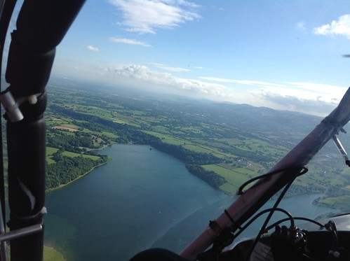
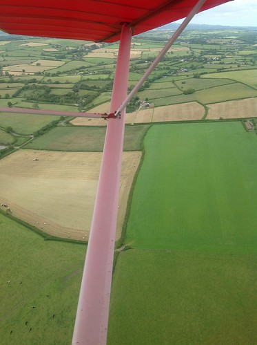
Llandegfedd on direct route
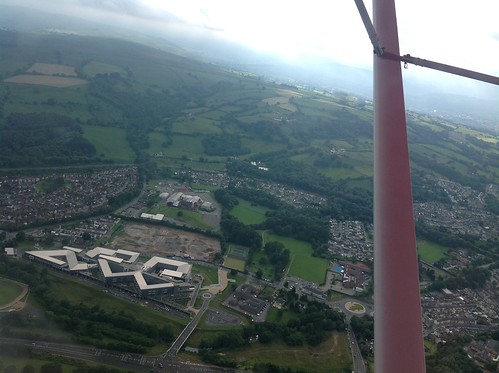
Ystrad Mynach - still sort of okay-not-brill but we want to go to the top left of the pic and that's not...
By Caerphilly we were stuck ahead. We discussed fuel - still enough to go back to Cemais - and the fact the cloud broke up to the east and we may be able to get around it that way and reach the motorway, we also climbed to have a look and decided to give that a go.
Caerphilly - no passing it

Round the edge? Maybe...
No photos from there on because all of a sudden navigating and lookout became very important very quickly as it became apparent that it wasn't, after all something we could go around and in fact was getting worse around us right here as we flew instead of improving over the lower ground as we'd thought it would. We weren't flying into it - it was forming around us and we were already on the limits of both legality and common sense
A fairly uncomfortable 8 minutes later we reached the outskirts of Bridgend where the motorway cuts back towards the hills for a spell. and that little extra height was enough to change the vis from 'manageable at this silly slow speed and and height to 'nope no way this is daft.'
I came to the conclusion slightly behind my more microlight-focussed flying partner that we (and for 'we' read 'he' because he's the one with all the time on the aircraft!) were plain and simply going to have to land somewhere and in a state of still half disbelief I remember saying "Okay if we're really doing this, I've got a good field".
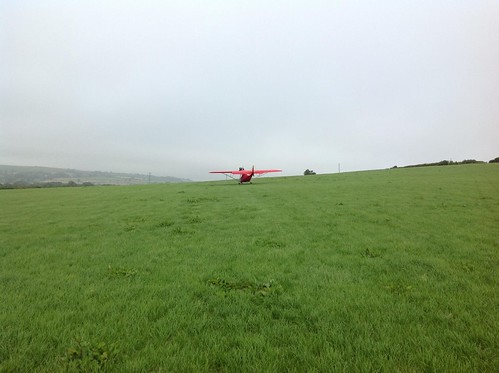
It was on my side of the aircraft and the one I'd been eyeballing in case of sudden silence up front and it really was the sort the textbook always has and real life obliges with less often. Open approaches, up on a slight ridge, recently cut silage, farm itself a field away in case we needed help.
Field on the right of the strut (taken the next day after leaving)
Given the speed with which things were deteriorating we were half in favour of landing at once, but I argued for a low pass for at least a looksee - peering down past the tyres at the grass with acute interest!
In fact the landing was as gentle as could be, a longer than average rollout - in amidst everything else we'd landed with a tailwind albeit uphill.
It was half past six and by the time we'd found someone, explained (they were great about it - did wonders for my opinion of human nature!), and secured the aircraft we couldn't see the tops of the telegraph poles.
It was way worse than the forecast had led me to believe so where did I mis-intepret it? Those TEMPOs and ISOLATEDs just all seemed to come together across the whole south Wales coast and valleys.
Should we have binned the flight on the basis of those? Maybe at least stayed local where we could keep an eye on it?
Looking after the fact on Weather Underground (what a useful site) you can see the point the temp starts to drop to meet the dewpoint but where in the forecasts could I have found temp and dewpoint data forecasts? Where was the clue that t-shirt weather was going to have us shivering on the ground 25 minutes later?
Was there something in the behaviour of the fronts that could have been a clue? Something in the cloud there was in that blue sky that indicated it was going to change and quickly?
Right this minute I don't really know how not to get caught again based on the data I had to start with...
Perhaps less discussed than post-engine failure arrivals into fields is the precautionary landing under power in that situation, yet we weren't in fact the only aircraft from our strip to need to do it yesterday, from two different departure points yet ended up close together in different farmers fields.
Hurt to nothing but pride (and bird doings on the aircraft which had to spend a night without her covers), we flew back today, but the other chap's awaiting a field trim before he can get out again.
I'm still trying to figure out what it was in the forecast that all three of us missed to find ourselves there. Amazing the data there is to pull through!
The TAF I got before leaving for the strip at midday was
EGFF 291102Z 2912/3012 29010KT 9999 SCT040
TEMPO 2915/2918 8000 BKN008
BECMG 2918/2921 8000 BKN006
PROB30 TEMPO 3000/3006 4000 BR BKN004
I frowned slightly over the "TEMPO 8000 BKN008" but the 'out the window' looked good, we were in no hurry and had no especial need to commit to a particular route and could dodge any nastiness. The 215 as far as I could see, concurred with much use of "Isolated" and "On Hillslopes" and "Coastal". Our strip's both and there was some cloud clinging to the hilltop but it was clearly visible and easy to dodge and once we were up we were past it and under blue skies in minutes.
215
Cloud along the ridge
With hindsight I completely failed to register the BECMG which proved to indeed become important. Because it was 1 o'clock we planned to fly - who cared what happened coming on 7...
Except we didn't actually leave until 4, didn't check the updated NOTAM at our destination, another little strip Cemais Commander, half hour away because the sky and conditions looked to the eye unchanged.
If we had looked again, we'd have seen this:
EGFF 291659Z 2918/3018 28015KT 9999 SCT008 BKN012
TEMPO 2918/2921 6000 BKN006
PROB40 TEMPO 2918/3006 4000 BR BKN004
PROB30 TEMPO 2921/3006 0400 FG BKN001
I don't know if we'd have believed it, sitting as we were in t-shirts and wishing we'd brought more water, but perhaps we'd have thought more about what was physically happening to change things. Maybe thought in particular about the little clouds we'd had to dodge above the hills north of the strip and wondered what was happening to them given this new forecast.
But we didn't and we set off home, taking off at around five past six (1705Z). It looked, if anything better than the trip up and we headed straight over the hills at first but turned south down the Rhymney valley when we crossed it and it looked like there was cloud ahead over the higher ground. We weren't down in valley to stay under the cloud - but because the cloud was overhead the hills but not overhead the valley. Weather deteriorated steadily but we were sure it'd break up once past the high ground and on reaching the lower lying ground around the M4. (It has before... Often! Another trap...)
Llandegfedd on direct route
Ystrad Mynach - still sort of okay-not-brill but we want to go to the top left of the pic and that's not...
By Caerphilly we were stuck ahead. We discussed fuel - still enough to go back to Cemais - and the fact the cloud broke up to the east and we may be able to get around it that way and reach the motorway, we also climbed to have a look and decided to give that a go.
Caerphilly - no passing it
Round the edge? Maybe...
No photos from there on because all of a sudden navigating and lookout became very important very quickly as it became apparent that it wasn't, after all something we could go around and in fact was getting worse around us right here as we flew instead of improving over the lower ground as we'd thought it would. We weren't flying into it - it was forming around us and we were already on the limits of both legality and common sense
A fairly uncomfortable 8 minutes later we reached the outskirts of Bridgend where the motorway cuts back towards the hills for a spell. and that little extra height was enough to change the vis from 'manageable at this silly slow speed and and height to 'nope no way this is daft.'
I came to the conclusion slightly behind my more microlight-focussed flying partner that we (and for 'we' read 'he' because he's the one with all the time on the aircraft!) were plain and simply going to have to land somewhere and in a state of still half disbelief I remember saying "Okay if we're really doing this, I've got a good field".
It was on my side of the aircraft and the one I'd been eyeballing in case of sudden silence up front and it really was the sort the textbook always has and real life obliges with less often. Open approaches, up on a slight ridge, recently cut silage, farm itself a field away in case we needed help.
Field on the right of the strut (taken the next day after leaving)
Given the speed with which things were deteriorating we were half in favour of landing at once, but I argued for a low pass for at least a looksee - peering down past the tyres at the grass with acute interest!
In fact the landing was as gentle as could be, a longer than average rollout - in amidst everything else we'd landed with a tailwind albeit uphill.
It was half past six and by the time we'd found someone, explained (they were great about it - did wonders for my opinion of human nature!), and secured the aircraft we couldn't see the tops of the telegraph poles.
It was way worse than the forecast had led me to believe so where did I mis-intepret it? Those TEMPOs and ISOLATEDs just all seemed to come together across the whole south Wales coast and valleys.
Should we have binned the flight on the basis of those? Maybe at least stayed local where we could keep an eye on it?
Looking after the fact on Weather Underground (what a useful site) you can see the point the temp starts to drop to meet the dewpoint but where in the forecasts could I have found temp and dewpoint data forecasts? Where was the clue that t-shirt weather was going to have us shivering on the ground 25 minutes later?
Was there something in the behaviour of the fronts that could have been a clue? Something in the cloud there was in that blue sky that indicated it was going to change and quickly?
Right this minute I don't really know how not to get caught again based on the data I had to start with...
"Let's go flying"
Scribblings of a novice PPL
Scribblings of a novice PPL


