Primarily for general aviation discussion, but other aviation topics are also welcome.
User avatar
By Flying_john
FLYER Club Member  FLYER Club Member
#1667376
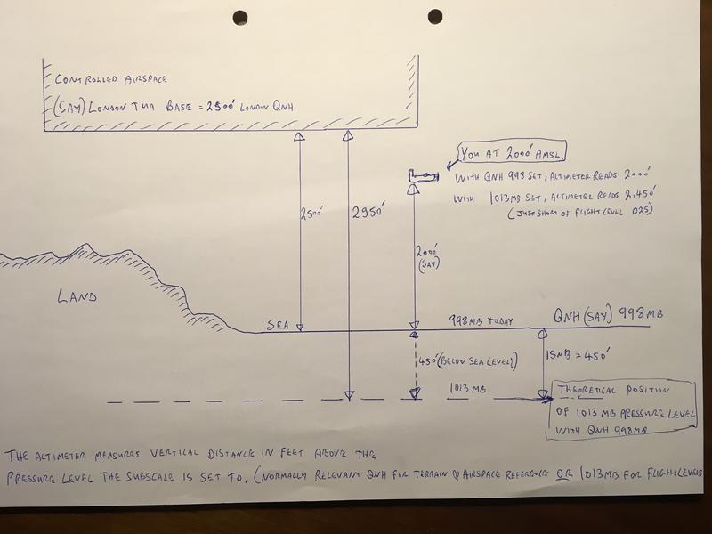
With about 18 millibars 540 feet difference between 1013 and local QNH today my trip took me from North Kent to Turweston. On the return leg with 0013 set and monitoring Luton, I hear our callsign.

The returns at Luton were showing us at 2600 - 2700 feet ( yes FL027 shown on Txpdr) and a request to descend.

Now my Altimeter and GPS altitude were varying between 2100 and 2200 feet, so well under the 2500 foot Class A.

So my question is how and when are the adjustments made in ATC for the transponder reported Flight Level to local QNH conversion, - or have I missed something and the transition Altitude is now very low and I should have been flying below flight level 025.

I am confused and interested as to what happens if I had been at 2400 feet on my local QNH and the 500 foot pressure difference showed me at 2900 - inside CAS on the transponder.

It was all very polite and I'm glad they called me, but I would like to know the science behind the Alt on my Txpdr (1013) and the local pressure altitude and why they thought I was in airspace ? Was there conversion factor wrong perhaps ?
By AlanM
#1667378
Non accusatory Questions;

Which QNH (not what QNH) did you have set?

Which QNH should you have set when flying around the LTMA (so near to any of the main London airports various CTRs/CTAs)?
User avatar
By alexbrett2
#1667385
As you have said, your transponder always reports flight levels (i.e. based on 1013.25)

You suggested 18mbar (or hPa) difference between 1013 and your local QNH, so I'm assuming you were flying on 995.

As such your transponder indicating FL027, would indeed put you at about 2160' on your QNH.

However, looking at Luton's METARs today (e.g. http://weather.uwyo.edu/cgi-bin/wyowx.f ... ATION=eggw), their pressure looks to have been notably higher than 995. If we assume you were flying when it was 1002, and you were at the top end of what your transponder would indicate FL027 on (probably 2750'), that is 2750 - (1013-1002 = 11, * 30' per hPA = 330') = 2420'

For the LTMA, what's important is actually the London QNH (as it is used throughout the LTMA) - this looks to be 1 or 2 hPa higher than Luton's today, so this might have been enough to put you 'inside', particularly if you bumped up 100' or so. Their reporting 2600-2700 to you doesn't fit, but I guess that could perhaps be a controller confused and reporting the raw FL rather than the converted altitude

Summary here is you might want to check where you got the 995 from, that looks suspiciously low for today, as looking at e.g. Lydd and a few other places, they all look to have been around the 1000 mark, so your 995 seems suspicious...
User avatar
By xtophe
#1667389
Looking at the metoffice surface pressure forecast only the Scottish Highlands were forecasted to have a QNH between 992 and 996 hPa.
User avatar
By Flying_john
FLYER Club Member  FLYER Club Member
#1667404
We were flying around 2:30pm - 3:30pm local and set Turweston QNH on departure - I cant remember 998 or 999 - Qsy'd to listening squawk on Luton and listened to other aircraft and reset/checked QNH to 998. The pressure had fallen since our 10:30 departure in the morning and so we were between 14 and 17 millibars different than FL (1013.2). So not 18 as first posted.

So at the time of the radio call aprox 15 millibars from 1013.2 - say 450'.

All three of our pressure Altimeters showed between 2150 - 2250, one steam two electronic and the GPS altitude was 2250.

The FL indicator on the Txpdr said 027. The nice man at Luton said it had shown us "popping up" into airspace at 2600 - 2700 feet.

As far as we were concerned - possibly in blissfull ignorance, we were at least 200 feet below London TMA.

But what happens if I had been at 2450 indicated and they had me at 2800 or 2900 - I am loathe to fly too much lower just for safety if the Donk stops, but the risk is a debate on whose kit was accurate and I am guessing the establishment wins the day !
User avatar
By Flying_john
FLYER Club Member  FLYER Club Member
#1667407
Lovely drawing

I think I am correct in saying the London TMA is not specified as a Flight Level though. So the drawing confirms my thoughts that one is dependant on whoever or whatever system does the "correction" from my transponder FL 027 to an altitude using the QNH for the area.

It would be of interest to know how that is done - is it minute by minute or hourly, a machine or a human, is it prone to error perhaps ?
By johnm
FLYER Club Member  FLYER Club Member
#1667414
No but it would probably be lower than the London TMA and setting nearby airport or TMA is the better practice than setting RPS which is an anachronism
AlanM liked this
By JonBoy
#1667419
Hi Johnm, yes you are totally correct - if the base of the controlled airspace is quoted as an altitude then Flight Levels/ 1013mb etc is irrelevant. I only included it on my drawing as an extension to basic altimetery principles...! :D. Only if the base of the airspace is published as a Flight Level (ie many airways) would you need to set 1013 to monitor your clearance from the base.

I suspect that your transponder will be pumping out some sort of signal to ATC referenced to 1013 though. I think that ATC will have some sort of trickery in their kit that will transpose that to an altitude of whatever they want to see.

From your story it sounds like you were exactly where you intended to be altitude-wise and happy you were not infringing anything. Could it be that your transponder’s altitude output is on the blink...?

Ps. Personally I think RPS (formerly Regional QNH) is as much use as a wet piece of toilet paper. Just use the QNH of the nearest airfield, much more accurate - or in the case of avoiding controlled airspace such as the London TMA the relevant QNH, in that case the London QNH.

Ps2. I would do exactly as you do, fly right up to the base of the airspace if I want to, with say 100’ buffer.
AlanC, AlanM liked this
By Lefty
FLYER Club Member  FLYER Club Member
#1667449
Two weeks ago,a group of us flew to Old Buckenham and had a similar experience with Lakenheath. They complained that a couple of our aircraft transponder outputs were showing us inside controlled airspace and setting off his alarms. Upon checking the QNH with them it was clear that we were a comfortable 2-300’ below the CAS.

Upon verification of our “real” altitude, the Lakenheath controller asked us to either descend 200’, or deselect ALT until we passed clear of the CAS fillet.

As with the OP, we were very surprised that the controller could not simply correct his system with our “True” altitude, but had to ask us to take action to fudge his system. Odd ..... ?
By ChrisRowland
#1667453
It's not a difficut correction, a subtraction, a multiply by a constant, and an addition.

The problem with this is that it tempts people not to use listening squawks - or even transponders. It's not what is wanted but if people get hassled it will put them off.

I flew over Kidlington last week, with the LS. On the way out I got a request to change altitude to avoid people practicing the hold, on the way back nothing. Happy with that.
Nick liked this
User avatar
By JonathanB
FLYER Club Member  FLYER Club Member
#1667454
Lefty wrote:As with the OP, we were very surprised that the controller could not simply correct his system with our “True” altitude, but had to ask us to take action to fudge his system. Odd ..... ?


It’s highly likely that the radar picture will have been using an appropriate QNH to convert the output FL from the transponder to altitude to display to the controller. However it’s also highly unlikely that a controller can apply corrections to individual aircraft returns to compensate for inaccurate data being transmitted.