Primarily for general aviation discussion, but other aviation topics are also welcome.
By PaulB
#1299676
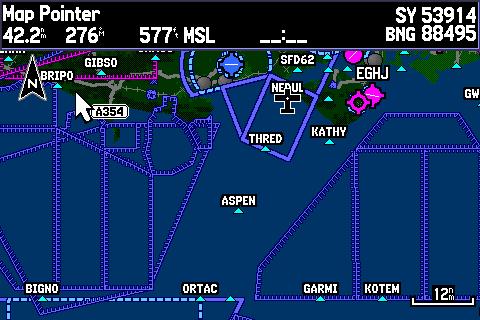
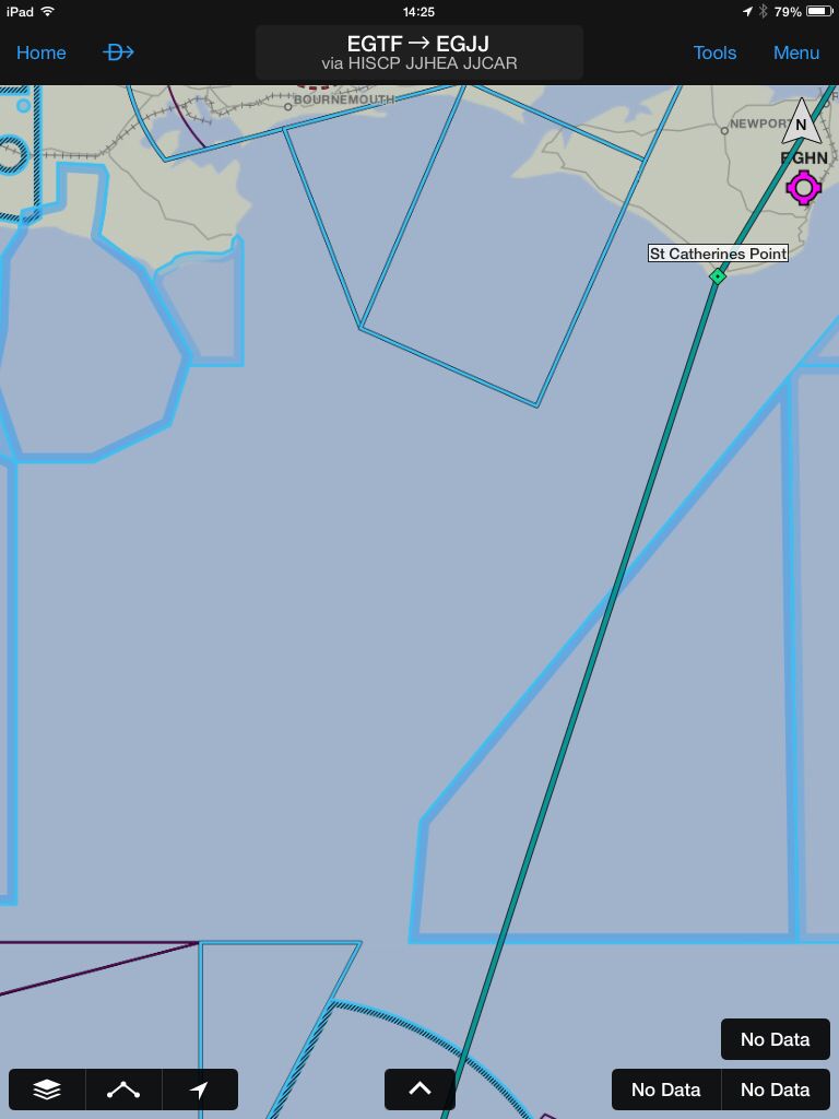
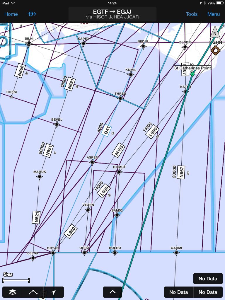
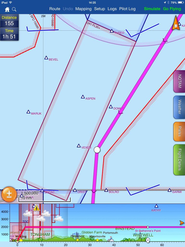
The omission of this airway (Q41 Base 3500' from S of Southampton to the Channel Islands) has often been mentioned when there have been discussions about the use of GPS. My Garmin 296 does not show it, but it's on the CAA chart and on Skydemon and (I assume) other GPS devices. It doesn't however seem to appear on the new Garmin Pilot software for iPad/Android.

What is it about Q41 that causes it's omission? I assume that Garmin's source of airspace data is official, so why is Q41 not on it, yet it does seem to appear on other GPS devices?
User avatar
By mmcp42
#1299678
ISTR some excuse like
"it's an airway, which is class A airspace
you're VFR so you don't need to worry your pretty little head about it"

crazy as you DO need to know so you keep out of it!
User avatar
By Irv Lee
FLYER Club Member  FLYER Club Member
#1299689
That's not the reason, it isn't class dependent. The GPS which don't show it (and it is not manufacturer dependent) can't show it - by design - the reason being they use a database designed for IFR use and use it for a device targetted at VFR pilots, and the IFR database only needs the centreline coordinates and doesn't need the edges. It isn't just Q41, it is any simple airway, there are other missing around the country, the Q41 is only quoted as an example as it is easy to detect that it is missing as there is no clutter between Solent and Jersey. There should be an airway here base FL035 between THRED and ORTAC through ASPEN
Image

(ps: I thought 'TH' was not used in airway reporting points)
By PaulB
#1299699
....but I can't even see the centreline on the screenshot above (or on the Garmin Pilot this morning). The airway appears to be completely missing.

With my 296 I had to import a 3rd party obstacle database, was this for the same reason? Where do GPS devices get their obstacle databases from?

Do SD and the like use both databases or just the VFR one?
User avatar
By Irv Lee
FLYER Club Member  FLYER Club Member
#1299701
It is missing - they don't attempt to draw the centre line. They want to draw the edges of the airway for VFR pilots, but can't -they depend on the warning messages about 'no primary nav' etc on boot up to cover themselves
By johnm
FLYER Club Member  FLYER Club Member
#1299702
The database for the Garmins is basically a Jeppesen product as I recall. As to reporting points who could resist NEDUL and THRED off the Isle of Wight :-)
User avatar
By Howardlong
#1299703
In GP, if you press the layer icon, select Map/Chart, then under Map select IFR rather than VFR then Q41 shows.

Practically speaking, for VFR, I would have thought it would be essential to know the airway existed and its width, or else you'd almost certainly wonder into class A airspace on a simple VFR trip to Jersey from or via Solent. It does rather make me question the value of GP for VFR flight planning purposes.

I haven't been flying with GP, does it give warnings like SD does of controlled airspace ahead?
By PaulB
#1299708
Howardlong wrote:In GP, if you press the layer icon, select Map/Chart, then under Map select IFR rather than VFR then Q41 shows.


The full width or just the centre line?

Would this be IFR charts in addition to the VFR ones or do you lose the VFR stuff?


How do SD et al. make this visible on a VFR chart?
User avatar
By Keef
#1299710
I just checked the Garmin Aera: that doesn't recognise the existence of Q41 either. It's as well I do my plogging with a paper chart and Navbox, and then transfer the route to the GPS afterwards!
User avatar
By dublinpilot
PFMS Team
#1299712
How do SD et al. make this visible on a VFR chart?


PocketFMS was the first system to show these correctly.

The problem is two fold.

Firstly for most countries, an airway is simply a route. They don't see it as an airspace block with a classification. So all the American companies don't include this on a VFR system, as why would a VFR pilot be interested in a 'route' that is only applicable for IFR? They don't see it as a block of airspace.

Secondly, the official definitions are centrelines and a width either side. Many merge into CTA's, TMAs & CTRs. Therefore they are difficult to plot correctly, and there is no database which takes all this into account.

A good example is the north Welsh coast, between the Isle of Man and Liverpool/Manchester. Plenty of merging here.

As far as I'm aware, PocketFMS (EasyVFR) and the CAA charts are the only ones who go to the effort of merging these correctly to make it easy for the pilot to discern the real borders.
User avatar
By SteveN
#1299718
Just to round this off, Q41 on PocketFMS (EasyVFR).

A anomaly of course now that Jersey is D up to 8000ft.

Last edited by SteveN on Fri Jul 25, 2014 2:50 pm, edited 1 time in total.
By SteveX
#1299722
So it appears on official documents (like the CAA charts) but not on non-official non-certified devices (like portable Garmin GPS). What is there to discuss?
By PaulB
#1299725
Where are the official charts designated as such?